Showing posts with label adventures. Show all posts

Sunday, July 26, 2020

Owl's Head: July 25th 2020

We live in the age of Instagram. 
Activities can only be considered successful, and interesting if there is a pretty (and perhaps heavily filtered) photo to prove your accomplishment. 

As I contemplated the many (many) complaints that I had heard about hiking Owl's Head, the biggest complaint was certainly the lack of splendor. 
No photo ops. 
No magnificent summit to pose on with friends and family. 
No bang for your buck. 

Listen. I'm not about to get all profound. But I really do not believe that success is measured in instagram likes. You can enjoy something without the carefully curated photo op.  
(and you can also enjoy the bejeebus out of sharing your adventures! Heaven knows I do. But I live for the adventure, not for the likes....)

That being said. Go like the hell out of our new YouTube Channel!! Give us SO MANY LIKES (I'm such a study in contrasts!)
Here is the progression: Our YouTube skills progress from BAD, to OK and we hope to get to DECENT. (but don't hold your breath.)

Anyway.
As we embarked on out quest to tag Owl's Head early on the morning of July 26th, I was fully prepared to suffer. I doubted that I would hate the hike, as I tend to enjoy the oddball adventures. But, I had my doubts about liking it at all.  Mostly, the things on my mind were my concerns about the potential tackling of our first bushwhack (more on that later) and my hopes that the water level readings I was seeing were correct . My biggest fear regarding this hike was NOT the low value summit, but coming to the first river crossing and having my dog swept away by the current. Luckily, it's easy enough to get the info you need about such things, and I was cautiously optimistic.

We arrived at the Lincoln Woods Trailhead before 5:30AM to find it jam packed full. We easily found road parking about 0.25 miles away, but knew it was bound to be a busy day. 

Our hike began as we knew it would, on the bone flat Lincoln Woods Trail. 
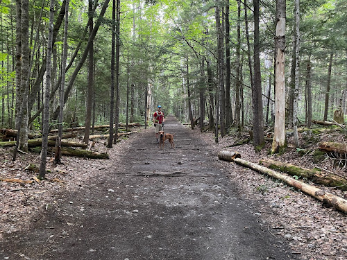
I mean.... How can you be mad about this?? #easy

At mile 2.8 we took a left onto the Black Pond Trail. I had researched the Black Pond Bushwack, and knew it would cut a bit of mileage off the hike (plus 2 major crossings and some odds-and-ends stream crossings) Armed with knowledge, the Gaia app locked and loaded, and a map and compass (although a map isn't terribly useful in this situation) we proceeded on a pretty obvious herd path. 

Which promptly vanished into the woods. 
Feeling 100% uneasy about this (even with Gaia in hand) we bailed and got the hell out. No point in flapping around in the woods all day. 
I'm not going to lie. The detour was worth it, as it was lovely. 
And it was also good to bail. If your gut tells you no, listen. 


OK. So with and extra 2 miles already in hand, we were officially off. 

I highly recommend sticking to the standard route (Lincoln Woods, Franconia Brook Trail, Lincoln Brook Trail, Owl's Head Trail) as you can totally zone out and go into autopilot.

So. It's really as easy as that. Take the bone flat super highways of Lincoln Woods and Franconia Brook. (there are a couple baby crossings on Franconia Brook) Bang a left onto Lincoln Brook. Shortly, you will hit the major river crossing (this is the one to worry about in high water, for sure.)

Big, wide river. No shoes required. 

While there are a few pointless ups and downs on this Lincoln Brook Trail, it is still extremely straightforward. After your second "real" river crossing, you will see where the Black Pond Bushwhack comes out on the left. I can see the reason of the popularity behind this *trail*. You do avoid two of the big crossings, including what is clearly the most daunting. (even though it was a low water day, we needed to wade across in shin deep water. very pleasant, it was hot.)

You spend 3.4 total miles on Lincoln Brook trail before coming to the "trail head" for Owl's Head. 
There is no sign.
On this day, there were two obvious rock cairns on the right, to mark this turn. 

Don't blink. Trail head.

Because I was keeping an eye open for them, they seemed obvious. However, 50% of the people we later met said they blew right past them (the mileage on my GPS measured the trailhead at 3.3 miles- but I do not trust devices 100% in such thick woods.) 

From there, yes. You go straight up. You gain like, 1500 feet in one mile. 

While it is a grind, it's not awful. It's a cross between Hancock and Flume slide. We all enjoyed it, if you want to know the truth. Plus, you FINALLY get your instagram photo!! (I took one! Believe me, I am not above the insta!)
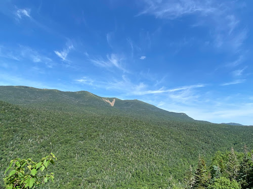
INSTAGRAM PIC

You are NOT "there" once you reach the top of the slide. You wind, and wind, and wind through the lovely woods for about .25 before you find an unassuming cairn which marks the top. 

Summit

As we made our way through the final .10 of the trail, we crossed paths with another hiker. "Did you love the epic summit?" I asked him. He laughed and said "Getting to the top of this mountain is epic enough."

That. Is. Correct. 

We did take the Brutus Bushwhack on the way down (at the BIG boulder- take a left. It is indeed a herd path and completely bypasses the slide.) 

From there, we happily retraced our steps and reentered the CHAOS of humanity once we reached Lincoln Wood Trail. THRONGS of people. (we saw fewer than a dozen people heading to Owl's head. Then at least 100 in the final mile.)
Honestly, it's weird being alone in the wilderness all day, and then return to the screaming mayhem of people (who apparently think that being outdoors excuses all kinds of bad behavior....?)
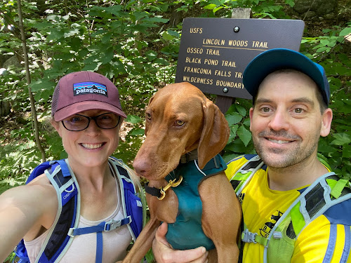
DONE

We checked back on at our car 9:50 from when we began, and the insane traffic was just too much, so off we went. 

This is one that I'm glad to have been able to check off the list. You really do need decent day to do this one- I would NOT suggest heading out after major rain, if there are storms in the forecast, or in the early spring when snow melt is an issue. 

You can easily find water data Here
People who I have talked to say that the crossings are difficult for humans when the levels are above 200, and not recommended for dogs until they are 50/60 (it was about 150 the day we went- and we all felt very, very comfortable.) 

One more word of wisdom. 
If you plan to hike ANY trails get a map, learn to use them. Get the White Mountain Guide, read it. Use internet groups to assist, but be responsible for educating yourself. If you choose to use your phone for any type of navigation, prepare for it to die and have a back up plan. (and pack your damn 10 essentials!!)

All 3 of us were pretty worn out after this adventure, but I'm feeling satisfied with the whole experience. Yes, it is a long way to walk for a 4025' hill. But getting to the summit is always half- or 99.9% of the fun, and if you love a good (FLAT) woods walk, you will love this one. 

Even Ellington was tired!!

I liked you Owl's Head. 
Next time (next time??) I will pack light, and run a good bit of this as it is a trail runners dream. I'm actually weirdly excited about trying that out. I like to be in the wilderness. I like the path less traveled. I do not like Lincoln Woods Trail in July......

Stats:
-21 miles
-3440 ft elevation gain
-9:50 min total time (at LEAST 30 min stopped time. We/Ellie need to eat.) 
-Difficulty: EASY/HARD/EASY
(don't be an idiot and try to do this one if you don't have your shit together. there is no cell service. that's all most people need to know :-)) 


Wednesday, October 9, 2019

Training for Marine corps Marathon: Week 15

The unique training continues. It was a pretty busy and exciting week, but pretty active (thought not in the traditional "countdown to the marathon" way.)

Tuesday was "mile repeat" day on the bike. A 1 hour 20 minute workout, with 6x7 minute repeats that were uncomfortably hard. 

Tuesday was a 45 minute bike workout, and 15 whole entire minutes of PAIN FREE running!!

Wednesday was "long run" day, with a whopping 25 minutes of running (!) and 2 hours on the bike. 

On Thursday I traveled to Aspen, for several wonderful days with my sister. 

We were SUPER active (despite the elevation that she lives at- over 8,000 ft!) 

We did a total of 14 miles of hiking, and 14 miles of leisurely biking (but at altitude, still a workout!) Of course, we also rode gondolas, took scenic drives, enjoyed local food and beers (as well as sunsets on her deck, which offers the most incredible scenery!!) The two of us just happen to be active people , so the days were delightfully jam packed with adventure. 

Just a casual lake at 11,000+ feet

LOVE MY BIKE????? 
So, normally this would be the start of tapering. Given the lack of abuse that cycling workouts give your body, I plan to more or less chug along for the next couple weeks. My hope is to get my running time up to about an hour this week (like, an hour for one run) and see what happens. I am operating 100% pain free currently, and I plan to continue that trend. 

Friday, December 28, 2018

Winter Hiking: Mt Pierce, December 26, 2018

Eric and I had planned a huge late fall/early winter hiking. However, the weather in November was nothing short of unreasonable! We got over 30" of snow (thankfully, not in one fell swoop.) It was very cold and dreary, and really quite aggressive for November.

I, in particular, did not really have winter hiking gear and we certainly were dealing with winter conditions. Oddly enough, December was way more laid back in the weather department. I believe we actually had more snowfall in October! (however, it was winter. And I had no winter hiking boots, no micro spikes, no warm gloves, basically I had jack shit.) So fall hiking plans: CANCELLED

But I did what any reasonable person would do, and I asked for *everything* for Christmas.
(and confidently planned a day hike for the 26th, taking a bit of a risk that I'd get enough kit to tide me over!)
Well. Not ICE or SNOW or ANYTHING shall stop me!
Luckily, I hit the jackpot, the weather cooperated, and even Evan was able to make the trip for some winter adventuring!

Some of us (*ahem ahem* ME) might have had one too many Barley Wines on Christmas, and may have awakened feeling a little shitty. Luckily, I quickly bounced back. (I am too old....)

We headed off to climb Mt. Pierce. We had concluded that it was the ideal place to test out our new apparel, remain below treeline for as long as possible, and to be on a trail that we know pretty well. Safety first.

Getting ready
It was about as good of a weather day as we could have hoped for. It was about 15 at the base, and hovered around 10 degrees for the majority of the climb.

The trail was in perfect shape. They had a decent rainstorm the week before, which had us concerned about ice, but the trail was glorious firmly packed snow. (completely covering the infamous White Mountain rocks, and essentially creating a superhighway. It was amazing!)

WHERE ARE YOU ROCKS?????
Evan tested his new crampons, and Eric and I opted for micro spikes. All of us were very happy with our choices, and there were no wipeouts (miracle.)

It was definitely a day for a few un-layering (un-layering..? De-layering? Undressing..) breaks on the way up, as none of us really wanted to get sopping wet and freeze to death.

Removing layers. Eating frozen granola bars.
The weather below treeline was really pleasant (it strongly beat out hiking in the summer humidity!) It was fun to see the winter transformation of an area that we saw several times last summer.

Winter Magic
We really only had one little inconvenience. It was pretty amusing the way we were all fighting with our food. ALL of our snacks and sandwiches froze solid. I did my best to keep my camelback functioning but it was a lost cause (I drink and blow back to keep the line clear, but the mouthpiece repeatedly froze and the whole bag of water ended up being too frozen to be viable. Definitely considering a different method for next time...!)

Nearing the alpine zone, the weather began to get chilly so we tossed back on our layers. The hikers we met coming down appeared to be dressed for Death on Mt Everest, and we assumed there was a reason for this!
Almost there
And yes. There was. As soon as our heads peeped above the trees IT GOT COLD. And shockingly windy!
Love the snowy trees. And the cloud. 
One of the reasons we picked Pierce was the teeny amount of time that one spends above treeline. We really did not regret this choice, and we all learned something about additional clothing that we need if we plan to venture any higher this winter. (example: I need a coat with a hood. A warmer hat. And to remember my ski goggles.) (it should be noted that I basically grabbed my barn jacket and called it good, I could seriously stand to upgrade: suggestions are appreciated!)

We basically tagged the peak and fled! It was not a day to dawdle. Evan's nose looked like certain frostbite and I noticed that my hat had the weather stopping ability of a screen door.

Just imagine the rest of the Presidentials behind us
Oh, and notice what rolled in? The typical big cloud. EVERY TIME!!!

Once we were back in the cozy forest, I felt a pair of eyeballs on me.

Oh Hello
And I met a new friend!

I LOVE YOU!!!
We definitely stayed bundled up on the walk down (despite the fact that we charged so fast that we were down in just over an hour....) But really, it was a lovely day once we were off the summit.

I enjoyed the hike down, although I noticed my boots need a bit of breaking in. It was especially nice not to have any rocks to deal with- so very rare! I might end up being a huge winter hiking fan. The three of us had our typical ridiculous conversations (most of which revolve around either being hungry, needing $15 heli evacs, or some other topic of equal absurdity!)

We had to take the typical bridge picture. (it was a tricky day for photos, because of cold hands...)

Yep, another bridge
We decided not to take a dip today!

Ice bath, anyone??
And then, just like that, we were back. It was REALLY fun!!

Another adventure in the books
All of us really enjoyed this experience, and are eager to do more. We were very mindful of the dangers of weather, and trail conditions and had all the supplies we would need to survive if we became incapacitated. (with the notable exception of easily drinkable water. would have had to melt some snow...) I always think preparedness is the key to a good time, and we all realized what we did correctly, and where we can improve. Looking forward to next time!

Stats:
Time: 3 hours 20 minutes (legit 25 minutes of clothings changes and bird holding)
Mileage: 6.1
Elevation gain: 2,379
Challenge level: Easy/Moderate. Pierce is just a great mountain, and a wonderful one if you are taking a crack at your first 4K footer. Yes, there are a couple somewhat steep spots but nothing dicey, or technical and no major water crossings. A great hike anytime of year!

Signature

Tuesday, October 30, 2018

Hiking in the Pemigewasset Wilderness: Lincoln Woods/Wilderness/Bondcliff trails.

At some point during the hot, oppressively humid, and generally disgusting summer weather I began to think about fall hiking. Knowing that I was straight out at work until mid October I began to concoct a plan. I concluded that on October 27th, after having a few days to catch my breath post insanity, Eric and I would head to Lincoln to climb Bondcliff (and maybe peak bag Bond if the weather was good.) I locked the day down ages ago, really looking forward to a final long hike in ideal conditions.
Back in July, an October trip to the wilderness seemed great!
I was imagining cooler weather (at the time, and after such a hot summer, I was assuming 50's) amazing foliage, and a day to relax and enjoy the mountains.

Right.

The weather has a way of doing what it wants. And what it wanted to do was snow. And be really cold. And windy.

I tracked the forecast (as one does) and concluded that if we started early, we could reach the peak of Bondcliff and bail before things got ugly. (with 100 km per hour winds scheduled for 7PM there was NO WAY IN HELL that we were risking a late day.) The Lincoln, NH area appeared to be getting mostly rain, and it looked like we might see a bit of snow on our return trip to Maine.

Wishing to get an early start, and not really relishing the notion of yet another 1:30AM wake up time, we drove to Lincoln and stayed the night before. We love the "off" season, because it makes staying over a reasonable, and affordable option.
I avoided watching the 18 inning Sox game, and we awoke (somewhat exhausted) at 3:30 AM (basically when people were finishing up drinking beer/watching the game, and switching to drinking coffee/getting ready for the first day of the Maine deer hunting season.)

The weather was just fine. 33 degrees. No precipitation. No wind.
We drove to the Lincoln woods visitors center in the dark, paid our $5 to park with the other 3 cars, and made our way to the trailhead. The place was deserted. (just the way we like it!) But also not a day to get ruined out on the trail, and hope for other hikers to wander by and offer aid. So, with our safety first mindset firmly in place, off we headed into the dark.

The suspension bridge over the Pemigewasset River
And were immediately warned about the bothersome bear. (clearly, this photo was taken on the return trip...)
Watch out
Armed with our usual headlamps and such, we struck off on the Lincoln Woods trail for 2.9 miles. It was BONE FLAT, and we covered this section in less that an hour. It was a great way to warm up, and to figure out our layering strategy to stay dry/warm throughout this long, flat section of trail.

Typical dark start. 
Honestly, this was basically a walking path. Later in the day, despite the weather, we saw many usual walkers, families, and children strolling along this path. (so. very family friendly.)
This trail is an old railbed, which means you'll be seeing a lot or railroad ties, ironware, as well as remnants of old logging camps. When we made our return trip in the daylight, it was definitely interesting to look around and take in the history (although I'm a bit concerned that when we do the Pemi loop at some point, that we might all die of boredom during the miles of endless flat!!)

After the 2.9 initial miles, you go over a suspension bridge and the trail is no longer very bike friendly (or, bike legal.) The trail, at that time becomes the Wilderness Trail (with zero fanfare) and while it narrows slightly, is still completely flat. We really motored this whole section, averaging over 3 MPH (this would be a very easy section to run. but we carry too much stuff.)

We did have a bit of trouble finding the junction where the Bondcliff trail veers left around mile 4.8.

It would be helpful to have this trail marker where the trail turns left. But nope. (so don't turn left when you see this sign!!)

We came to what appeared to be a stream crossing, and, with our eyes being drawn across the brook to a "no camping" sign (very reflective off the headlamps) we crossed the icy stone brook (where I promptly slipped, dunked my whole foot, and had to do a hasty sock change.)
After puttering about for a bit, and consulting the map, we turned around. Thanks to the increasing daylight we were then able to see the sharp left turn (and the very, very faint light blue blazes that would continue to appear *sporadically* for the remainder of our trip.)

After that little misstep, we continued without issue. I will say though, that this stretch of trail was not well marked at all, at least to the more casual observer (which I am not, as I do not wish to become lost in the woods.) The trail was heavy with fallen leaves, and in some places you really needed to be quite observant about where you were going. Probably solid advice, no matter where you are hiking.


There were a couple miles of winding, very wooded trail with some fairly dry stream crossings. I imagine these could be problematic in seasons with snow melt, or heavy rain.

One of many stream crossings
Compared to what we have come to expect in the Whites, there were few rocks. (don't get me wrong. There were some. But nothing compared to the boulder city of Madison, etc)

Very typical stretch of the lower part of the Bondcliff Trail
Gradually, we began to find the remnants of a fairly big storm that the area had experienced several days before. While some of the White Mountain region got a few feet of snow, there were only a few inches here. And someone had kindly tramped it does for us!

Just a bit of snow
For the most part, despite the continued lack of blazes, the trail was easy to follow. There was a fairly twisting section at one point which may have been challenging to follow, if we were not following footsteps from the previous day. With that one exception, you essentially follow the narrow path.

As we climbed, the snow become deeper but was not at all problematic. It actually managed to nicely pad some of the rocks, which were surely buried underneath! While there were a couple steeper sections of the trail, they were fairly short lived. The hike is more of a slow and steady climb. You have just over 9 miles to reach 4,265 feet so you won't be redlining the whole thing.

Knowing that we were just ahead of a pretty major winter storm, when the wind took on an ominous feel we decided to play it safe and turn around (even though we were sooooo close. We probably had about a half mile climb left to go.) Oh well though, it is better to be the hikers who bail, than the hikers who need the heli evac (and even though Evan was not with us, our summer long "Heli Evac" chant certainly came up once or twice...)
Winter in full effect
The decent was straightforward and flew by. Before we knew it, we turned right onto the Wilderness/Lincoln Woods trail.
One still gets tired after a 17 mile day, even if some of it is flat!
We then proceeded to zip along for the 4.8 miles of bone flat superhighway back to our car.

Bone Flat Superhighway
With about a mile to go, the freezing precipitation began.
On a nice day, we would really have enjoyed the scenery more (that's going to be the plus side of the endless, pin straight, pancake flat final section of the loop. We will at least have things to look at!) We chose not to take the .4 mile detour to see Franconia Falls, which we have heard is fantastic. We basically just put our heads down, and trudged on. (and looked at the bridges, because I love them.)

I've never met a bridge that I didn't want to take a crappy photo of
After going the whole day with zero human sightings, the floodgates opened and we saw a ton of people. Clearly, the Lincoln Woods Trail is very popular for the family walk crowd, even in crap weather, and I imagine it is a complete zoo in the summer. I believe there are some swimming holes in the river, that are very popular.

Much of the Lincoln Woods trail is next to the river
The temperature remained at freezing all day, (although it was much colder when we were close to the summit.) Basically, shit was frozen.

Pretty though
We made it back, uneaten by the bear.

And honestly, with the weather rapidly worsening, we were not disappointed that we had turned back.

You can see the ice on my hat


The drive home was a shit show of epic proportions. The end.

Fucking aggressive 

Stats:
Time: 7 hours 10 minutes (included around 30 minutes of trail location in the dark....)
Mileage: 16.9
Elevation gain: 2,630
Challenge level: Easy/Moderate. The almost 10 miles of flat made the one of the most straightforward hikes we have done. The climb itself was also pretty benign, although we missed the one lone scramble at the end. I suppose I must give this hike a moderate rating due to the distance, and the need to be extra attentive to the route at times. However, I would certainly give it an easy for terrain. You could most definitely bring your non-hiking friends on the first 4.8 miles of this trail with zero issue. 

Signature