Showing posts with label Hiking with Dogs. Show all posts

Sunday, July 26, 2020

Owl's Head: July 25th 2020

We live in the age of Instagram. 
Activities can only be considered successful, and interesting if there is a pretty (and perhaps heavily filtered) photo to prove your accomplishment. 

As I contemplated the many (many) complaints that I had heard about hiking Owl's Head, the biggest complaint was certainly the lack of splendor. 
No photo ops. 
No magnificent summit to pose on with friends and family. 
No bang for your buck. 

Listen. I'm not about to get all profound. But I really do not believe that success is measured in instagram likes. You can enjoy something without the carefully curated photo op.  
(and you can also enjoy the bejeebus out of sharing your adventures! Heaven knows I do. But I live for the adventure, not for the likes....)

That being said. Go like the hell out of our new YouTube Channel!! Give us SO MANY LIKES (I'm such a study in contrasts!)
Here is the progression: Our YouTube skills progress from BAD, to OK and we hope to get to DECENT. (but don't hold your breath.)

Anyway.
As we embarked on out quest to tag Owl's Head early on the morning of July 26th, I was fully prepared to suffer. I doubted that I would hate the hike, as I tend to enjoy the oddball adventures. But, I had my doubts about liking it at all.  Mostly, the things on my mind were my concerns about the potential tackling of our first bushwhack (more on that later) and my hopes that the water level readings I was seeing were correct . My biggest fear regarding this hike was NOT the low value summit, but coming to the first river crossing and having my dog swept away by the current. Luckily, it's easy enough to get the info you need about such things, and I was cautiously optimistic.

We arrived at the Lincoln Woods Trailhead before 5:30AM to find it jam packed full. We easily found road parking about 0.25 miles away, but knew it was bound to be a busy day. 

Our hike began as we knew it would, on the bone flat Lincoln Woods Trail. 

I mean.... How can you be mad about this?? #easy

At mile 2.8 we took a left onto the Black Pond Trail. I had researched the Black Pond Bushwack, and knew it would cut a bit of mileage off the hike (plus 2 major crossings and some odds-and-ends stream crossings) Armed with knowledge, the Gaia app locked and loaded, and a map and compass (although a map isn't terribly useful in this situation) we proceeded on a pretty obvious herd path. 

Which promptly vanished into the woods. 
Feeling 100% uneasy about this (even with Gaia in hand) we bailed and got the hell out. No point in flapping around in the woods all day. 
I'm not going to lie. The detour was worth it, as it was lovely. 
And it was also good to bail. If your gut tells you no, listen. 


OK. So with and extra 2 miles already in hand, we were officially off. 

I highly recommend sticking to the standard route (Lincoln Woods, Franconia Brook Trail, Lincoln Brook Trail, Owl's Head Trail) as you can totally zone out and go into autopilot.

So. It's really as easy as that. Take the bone flat super highways of Lincoln Woods and Franconia Brook. (there are a couple baby crossings on Franconia Brook) Bang a left onto Lincoln Brook. Shortly, you will hit the major river crossing (this is the one to worry about in high water, for sure.)

Big, wide river. No shoes required. 

While there are a few pointless ups and downs on this Lincoln Brook Trail, it is still extremely straightforward. After your second "real" river crossing, you will see where the Black Pond Bushwhack comes out on the left. I can see the reason of the popularity behind this *trail*. You do avoid two of the big crossings, including what is clearly the most daunting. (even though it was a low water day, we needed to wade across in shin deep water. very pleasant, it was hot.)

You spend 3.4 total miles on Lincoln Brook trail before coming to the "trail head" for Owl's Head. 
There is no sign.
On this day, there were two obvious rock cairns on the right, to mark this turn. 

Don't blink. Trail head.

Because I was keeping an eye open for them, they seemed obvious. However, 50% of the people we later met said they blew right past them (the mileage on my GPS measured the trailhead at 3.3 miles- but I do not trust devices 100% in such thick woods.) 

From there, yes. You go straight up. You gain like, 1500 feet in one mile. 

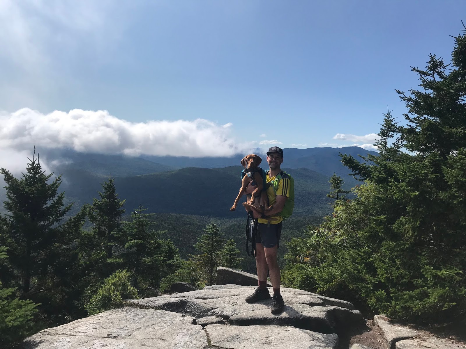
While it is a grind, it's not awful. It's a cross between Hancock and Flume slide. We all enjoyed it, if you want to know the truth. Plus, you FINALLY get your instagram photo!! (I took one! Believe me, I am not above the insta!)

INSTAGRAM PIC

You are NOT "there" once you reach the top of the slide. You wind, and wind, and wind through the lovely woods for about .25 before you find an unassuming cairn which marks the top. 

Summit

As we made our way through the final .10 of the trail, we crossed paths with another hiker. "Did you love the epic summit?" I asked him. He laughed and said "Getting to the top of this mountain is epic enough."

That. Is. Correct. 

We did take the Brutus Bushwhack on the way down (at the BIG boulder- take a left. It is indeed a herd path and completely bypasses the slide.) 

From there, we happily retraced our steps and reentered the CHAOS of humanity once we reached Lincoln Wood Trail. THRONGS of people. (we saw fewer than a dozen people heading to Owl's head. Then at least 100 in the final mile.)
Honestly, it's weird being alone in the wilderness all day, and then return to the screaming mayhem of people (who apparently think that being outdoors excuses all kinds of bad behavior....?)

DONE

We checked back on at our car 9:50 from when we began, and the insane traffic was just too much, so off we went. 

This is one that I'm glad to have been able to check off the list. You really do need decent day to do this one- I would NOT suggest heading out after major rain, if there are storms in the forecast, or in the early spring when snow melt is an issue. 

You can easily find water data Here
People who I have talked to say that the crossings are difficult for humans when the levels are above 200, and not recommended for dogs until they are 50/60 (it was about 150 the day we went- and we all felt very, very comfortable.) 

One more word of wisdom. 
If you plan to hike ANY trails get a map, learn to use them. Get the White Mountain Guide, read it. Use internet groups to assist, but be responsible for educating yourself. If you choose to use your phone for any type of navigation, prepare for it to die and have a back up plan. (and pack your damn 10 essentials!!)

All 3 of us were pretty worn out after this adventure, but I'm feeling satisfied with the whole experience. Yes, it is a long way to walk for a 4025' hill. But getting to the summit is always half- or 99.9% of the fun, and if you love a good (FLAT) woods walk, you will love this one. 

Even Ellington was tired!!

I liked you Owl's Head. 
Next time (next time??) I will pack light, and run a good bit of this as it is a trail runners dream. I'm actually weirdly excited about trying that out. I like to be in the wilderness. I like the path less traveled. I do not like Lincoln Woods Trail in July......

Stats:
-21 miles
-3440 ft elevation gain
-9:50 min total time (at LEAST 30 min stopped time. We/Ellie need to eat.) 
-Difficulty: EASY/HARD/EASY
(don't be an idiot and try to do this one if you don't have your shit together. there is no cell service. that's all most people need to know :-)) 


Tuesday, July 14, 2020

Mt. Adams Via Airline: June 14th 2020

It has been a funny season for hiking thus far.
Plan "A" had us wrapping up all the NH48 except the Bonds, and Owl's head during the very early Spring season. Due to COVID, we didn't even consider traveling to NH (even though it is about 4 minutes away) until June. 

Our other goal for the early season (originally planned, tentatively, to happen late June) was a full Presi with Ellie. 

Anywhoo. Weeks later now, we have postponed our Presi attempt until either:
a: a perfect day where we limit weather variables for maximum safely
OR:
b: next year. the mountains are always there

Because Mrs. Ellington was a little baby last year, we made no complete summits conquests in the Northern Presis. although we did play around Adams, just enough to stick our heads above treeline. 

After a week of the weather looking like crap, we woke up the morning on June 14th to a promising looking day, and off we went to conquer Adams, and to test Ellie's skill in the boulder field. 

It should be mentioned that Eric has beef with Adams. He kind of low-key hates it, and I can't completely argue the point. Every time we have been up there visibility has been zero. The wind has been INSANE. The rocks.... So slippery. So, Eric and Adams had a score to settle. 

We headed up Airline, as we had never done the whole trail and figured it would be a *good* time and a *great* way to tick a trail off the T25 list. Many good choices. 

Anyway. As promised it was, in fact, a decent enough day. And WEIRDLY, no wind. 

Airline was decent. Then rocky. Then kind of dumb. 

You can't judge the ups by the pic
Weirdly though, after this garbage section of trail it gets pretty decent again! Trickery. 

And.... As is the case with many of these silly hills, once you get above treeline it's a bit mind blowing. On airline, you basically teeter in space and can gawk down into the ravine and make wise choices about focusing, not tripping and falling. 

Just looking up for safety


Because I was 100% not focused on picture taking, I neglected to take a single shot of any of us making our way through the boulder field. 
But let me say this. 
It was a dry day. 
There WAS ZERO, and I mean ZERO wind. 
Visibility was as good as it gets. 
And Ellie was amazing. 

And, with GLORY in our hearts. we summited. 


Then (as you can see) we descended the boulders with success, walked over to the Madison hut, and came down Valley Way because it's easier than Airline. 

Success! A great day in the Northern Peaks. As far as T25 trails go, Airline is a piece of cake. (although you can REALLY appreciate how BAD it could be if you took a wrong step....)

We barely saw any people all day, except for a decent sized pack of noisy college aged humans. The weather was amazingly cooperative. It was a great reminder about the technical/fiddly challenges of the northern peaks that you just don't see elsewhere. AND, we were both delighted with how well the puppy handled the tricky terrain. Smart girl (and, because she is only about 45 pounds, her paws didn't even take a beating.)

Stats:
Date: June 14, 2020
Mileage: 8.5
Elevation: 4,447
Time: 5:50 (probably 20+ min of taking in the scenes, etc)
Challenge level: Difficult
Dog Friendly?? Completely, until you get above treeline. If you had issues with your dog on the way to the summit you must be aware that carrying them down could be very difficult. So proceed with caution. 

Saturday, July 11, 2020

Baldface Circle Trail, June 7th 2020

I'm running pretty far behind on my hiking recaps but there is a legit reason for that. I was only about 23% committed to writing recaps this year since they take up time and I wasn't entirely sure they would ever be useful to me.

HOWEVER. During the past week alone, I think I have sent people to various trip logs from last years adventures a minimum of 10 times. That's a solid week for me, since #Covid #nofriends but apparently I am regarded as the person with the info.

And, hence, the hiking posts shall continue, albeit tardily.

So WAY back on in early June, Eric and I had intended to make the drive to Rangely to hike Saddleback and the horn. Approximately 3 minutes into that particular morning, I took a bad step and hurt my back in a manner that made it difficult to sit. And that was that for the 2.25 hour drive each way.

Plan B, made hastily, was to scoot over to Evan's Notch and amble around the Baldface Loop. At 10-ish miles this seemed like a good trip for early season, and we felt pretty confident hiking in that area since we basically live there. I knew to go clockwise around the loop, as a couple ledges were said to exist.

We leisurely arrived late morning, to find a (typically) full lot. Too many little trails in that area make for crowded parking.

However, we saw very few people heading out and saw no people for the first couple miles. The first real human interaction we had was at the small camping shelter, which I believe was about 2.5 miles in. To that point, the trail was certainly on the easy/moderate side. A really pleasant walk through the lovely woods.

Just after the shelter, you see your first couple rocky ledges. My initial impression based on my research (brief research, I will admit) was that the ledge/scramble stretch was pretty short.
Well. Not exactly.

The beginning 
All the scrambling is doable, but be prepared to get your butt up some rocks. Don't be afraid of heights. Be agile and nimble!! And get ready to fiddle around on a rock slab for quite some time. The views make it TOTALLY worth it though, plus, scrambling can be pretty fun.

One of the first views. HELLO.
The best thing about this hike is that there is SO much to look at. We tend to do quite a few "walking through the woods" hikes, which I really enjoy. But sometimes, getting up above the trees is pretty fun.

Possibly the prettiest thing I had seen all year
Anyway. Eventually the one thing we couldn't help but notice was the 400MPH wind. It was insane. The most crazy. Like, my hat blew off.
But it was PRETTY AF.

Stop
I don't want to be a total fangirl but this was possibly one of the most lovely hikes ever. And stepping outside of the 4k obsession was absolutely fine, and something that I would consider daily, if all hikes were this perfect (and please don't forget the half mile of straight up rock, because you do have to cope with that.)

Loves scrambles
Between the South and North peaks were more views, (like, always) another short scramble, WIND, and then a view of where we had been.....

Remember those rocks from earlier??
Anyway. Lame blog. Lots of nice trail. Like, PERFECT except for the actual technical rock climbing part, haha. Beautiful flowers. VIEWS for DAYS. And nice woods. This hike was a real 10/10.

And then we came down, out of the hurricane wind, got back into the woods, crossed a perfect river and then we were done. THE END.

River
I hate to oversell this. But writing this over a month later has given me time to ponder what an actually amazing hike this was. I would go do it again tomorrow, but tomorrow we are hiking Cabot which must be done.... Unless you are not nimble and brave, go do this hike. Even if you aren't nimble and brave, walk to the first place it gets rocky (almost immediately after the shelter, going clockwise) take a look, and then go down (you really do not want to descend those rocks. so quit early unless you are committed.) The views are amazing, but more importantly, it's a really glorious trail experience.. This hike would not have been our first choice, and I'm actually kind of ashamed by that as it was one of the most enjoyable trails we have seen. Lots of variety. Lots of fun (maybe lots of danger, haha.)

Stats:
Date: June 7th 2020
Mileage: 9.6
Elevation: 3,484
Time: 4:55 (included 15-ish min of faffing around)
Challenge level: Difficult, only because of scramble
Dog Friendly?? ISH. Must be able to handle some rocks

Tuesday, May 19, 2020

Pandemic running week 9

Winter is over. The 10 day forecast has 3 days well into the 80's!!
There is no doubt about it, while I may be in better running shape at the moment than I have been at this point during the past couple years, the heat is going to slow me down.

Hello Summer

Last week went exactly as planned, logging 25 miles. My leg feels good, and I feel pretty fit (although it could have been the chilly, windy days talking....)
The snow from the previous week melted immediately and spring arrived. Yay! So did the bugs. BOO.

Spring
Eric and Ellie and I went on a tiny local hike over the weekend. The whole pandemic mess has completely disrupted our big hiking plans, but we are lucky to have local trails that have zero people on them. We plan to make the best of it!

Decent view for a tiny hill 

Evidently this week is the beginning of *theoretical training for Boston 2.0*

I plan to run 30 miles this week.

After that...

I'm just going to put in the work until the race gets cancelled for good, and then I am going to keep running.
I think I learned something important last year. Apparently, at 40, it takes a lot longer to get back into shape after a break than it does at 35. UGH OLD AGE!!!! Kidding though, I imagine in 10 years I will wish for the *fitness, speed, and excellent skin* that I have a 40 (because DAYUM, I sure look back 8/10 years ago and wonder WHAT the devil I was complaining about!!)

Here is what will be easy about Theoretical Boston 2.0 Training:
-I want to keep running.
-I am reasonably fit so it won't be, like, totally awful. Maybe?
-I do feel motivation not to fall off the running wagon. Because, as discussed, OLD.
-Not much else to do at the moment
-HEALTH....??? So much health plus many fitness goals. Pshhhh.

What will be hard:
-Well. Running.
-The fact that I don't believe I'm really race training. So, I'm going to have to trick myself into doing shit bag things like speed work and 18 mile long runs when it is 85, humid, and thunder.....
-Heat and humidity and all the dry heaving that causes.
-Possibly one million pandemic related things that I don't know exist.

BECAUSE WHO THE FUCK WOULD HAVE THOUGHT WE WOULD BE LIVING THIS????

I mean, seriously.

Anyway. I am healthy, my family is healthy, my business is about to reopen (although my summer side hustle is in serious jeopardy...) So... so far so good? ISH?

So next week. I will give a glorious report on how my majestic marathon training is going. Eric keeps saying we are going to run a beer mile, so maybe that will spice things up a bit (plus, more barf related posts, I imagine!)

Friday, August 30, 2019

Isolation! August 25, 2019

The night before this hike, we had decide not to attempt Isolation. The Saturday weather had not been as good as forecasted, we were a bit tired from Zealand: the extended version. And REALLY, who wants to get up at ass o'clock every day??

So, when Eric got out of the tent at 6:45 on Sunday morning and said "SHIT. We need to hit Isolation today!" I was both excited, and freaked out because one would have planned on an earlier start.

But yes, the sun was shining gloriously and there was not a doubt in our collective minds. It was a day for some above treeline nonsense.

We managed to get on trail exactly 9:30- which is a hideously late start. Thankfully, sunset is still on the later side so were not too worried. I had heard wildly varying times for this hike but calculated that we should/could be able to do it in 8.5.

And off we went.

Not too gross after a couple days in a tent
We chose the Glen Boulder trail to start with, and it gains some serious elevation right from the beginning. However, it tosses in some switchbacks, and moderate sections (so as long as you don't go out habanero- you will make it. We certainly saw some humans around mile .75 who were DONE for the day. Don't be those guys.)

Just normal up and up
As the trail pops above the treeline for the first time, there is the only technical scramble of the day. Our typically fearless dog took a good look at this little rock slab and asked for a boost. She was then on her way and had no other issues (this is just good to keep in mind if you have a cautious/old/arthritic/non-athletic dog. they might not make it up this.)

The view looking towards Glen Boulder was stunning. It was a perfect weather day, in beautiful surroundings.

Just a small rock on a hill 

It's kind of amazing that such a large rock decided to settle in this exact place. Let's hope it stays put.

Ellie is like, 50 feet away for perspective
After checking out the boulder, we continued to go up. A stretch of above treeline hiking, then  transitioned into some more wooded path.
There is a spring off this stretch of trail: be aware, this is the only easy place to get water for the remainder of the hike. If you have a dog, make sure to bring a LOT of water!

On the way to the intersection of Glen Boulder Trail, and Davis Path, you pass over a summit which is called Slide Peak, or Gulf Peak depending on what map you look at. While it is right at 4800 feet, it doesn't "count" because it doesn't have prominence. BUT- it has some killer views.

Right at about 5100 feet, 3.2 miles in, you come to the intersection with Davis, and make the left turn towards Isolation. (by the way, this was Ellie's highest climb!)

Can't beat the weather, or the view!
And then. YOU GO DOWN.
Might as well enjoy it though. The sights just don't get any more gorgeous.

Isolation, here we come
The little above treeline stretch was just glorious, but luckily, we both really liked the wooded sections too. You really drop like a rock, losing over 1k elevation pretty damn quick. You're going to hoof along in the woods for about 2 miles- and they aren't bad miles at all!! Then, you'll come to a fork in the road and take the right hand trail towards Isolation. Only another 0.9 to go at that point...!

A pleasant trail!
There are some pretty muddy areas on the Isolation trail, and I imagine it is a gross mess in the Spring. But I didn't take any pics that weren't pretty, haha.

And just like that (well. after almost 4 hours) there is was!

Yay!
Just a small climb and POP, above treeline you go.
To some of the best views you can hope for.

BEST VIEW
Just kidding. It was lovely.

Gotta get back up that, though
We could not have asked for better conditions. Save this one for a glorious day!

We made it!
We made it to the summit in almost exactly 4 hours. We did have to stop several times to water and feed the dog, and for minor outfit changes. Nothing major though.

After enjoying about 10-15 minutes at the summit, we were off again. Knowing we had a pretty solid climb in the way down was a good motivator not to dilly-dally.

The return trip was, honestly (and thankfully!) uneventful. Yes, there was a climb to get back to Glen Boulder trail. But: it was such a nice day, the surroundings were so fabulous, and we are in decent shape, so it was not at all horrible.
We retraced our steps, as I have heard that Rocky Branch is not in good shape. Plus, we don't always trust our hitchhiking skills.

BACK UP WE GO!
Gotta take a few to check out the view.

Just out of the tiny woods
Shadows were beginning to fall by the time we made it back to the big big rock.

Casts a large shadow
It was a good walk down. We had braced ourselves for being really tired, which never actually came to pass. We braced ourselves for some level of frustration, which also never happened! The dog got a little crazy at the end, but saved it for the final stretch so that wasn't even an issue. We had prepared for a real level of struggle (especially after hiking 12 plus the prior day) but it never was that bad. We had some good laughs on the way down, the trail is impeccably marked so we never had the "oh shit where do we go" feeling, like we had on the Twins, and it was a fine ending to a truly fine hike!

Elle is so embarrassed 
This was a great one.
Don't do it if you aren't in shape.
(good to note: there really is not a "bail out" option on this hike. so if you can tell it is not your day, head down earlier rather than later.)
Save it for a nice day!
AND ENJOY.
Also, this brought us up to #28 on the NH48 list (I believe, the 21st one we have done in 2019!!)  I really have to appreciate the list for being a motivator to get out and do a hike like this. Otherwise, I might have said "11.6 miles for a little mountain?!? NO WAY!!" And thus, would have missed out on a really fun day.


Strava data: (we take this with a grain of salt) 
-elevation climbed: 5,007 (HELLO!!!!)
-miles covered: 11.6
-elapsed time: 7:58

Difficulty: Strenuous. Very long, lots of vert. But amazing!!!! Very exposed in places, not a great option for a bad weather day. This route avoids major water crossings, but it can certainly get very muddy. You are, indeed, isolated out there. No viable bail out routes that would help you in a bad situation, so you must be smart to do this one. I did find some cell service in a few places, but it's very spotty. 

Views: Unbeatable. Even if you only go to Glen Boulder. 

Bugs: Nope

Dog friendly trail? Ish. One tricky scramble, and very long with very little water. Our little buddy loved it, but she's nuts. 

Signature

Wednesday, August 28, 2019

Zealand: The extended version. August 24, 2019

Eric, Ellie and I went camping over the weekend.
Since we were already ON the Zealand Road, we concluded that it only made sense to hike Zealand.

It seems to be a little talked about Mountain- people seem to tie it in with Hale (smart) or snag it during an extended Pemi (less smart??)

We got up, the weather was decent enough (cold!) we drove a couple miles up the Zealand road to the Zealand Trail lot ($5, packed, typical) We parked in the Zealand lot which connects to the Zealand trail and takes you to the Zealand hut and Mt. Zealand, BECAUSE EVERYTHING AROUND HERE IS CALLED ZEALAND! I think this is very amusing.

And we made a STARTLING DISCOVERY!!!!!


OH MY GOD?!?!?! IT IS??? 
I admit, the Thoreau Bridge closed signs are mostly a joke between Eric and me (and maybe not even a funny one...) But Eric and I find it very amusing, every time we come to a bridge, to politely ask one another if it is the Thoreau Bridge. And then shout "IT IS OUTTTTT!"
We think we are funny.

Anyway. It was like 45 degrees and off we went. 
Zealand Trail was very polite.

Yes please
THEN. Zealand Trail went through a swamp, and I LOVE SWAMPS!!!

Thoreau bridge!!!! Nope...
OMG stop. I love it.

It was a bit cloudy though to be honest. 
Anyway. We chugged along on the flatlands for a few legit miles, and then the trail turned upward by Zealand Falls, and headed to the hut. The trail to the hut which covers 2.8 miles, literally goes up 700 something feet. It is the least hard thing you will do all summer.

The only steep stretch in the first part
After passing by the hut you transition to the Twinway (the AT) which continues to be very reasonable, although somewhat more uphill. You pass over some little flumes, along some pretty rocks and through a lovely forest.
There is a viewpoint just before the Zeacliff trail that should not be passed by! This is right around 3.7 miles, by a sign that says "view". The sign is correct.
From what I understand, this is "Zeacliff" which makes sense, as it is a cliff. This is a tad confusing, since on the actual Zeacliff trail is another perfectly good Zeacliff. who knows.

Beautiful!!!
From there, the trail continued to be so enjoyable! Well marked, so obvious, perfectly maintained. Just delightful.

Doesn't get much better!
There were, as expected, a few uphill stretches but they were broken up perfectly by easier terrain. There were a couple (few) rock hops, the smallest of teeny baby scrambles, and one steeper section with a very doable little climb, and helpful ladder.

Mostly though, it was fun and straightforward.

Ellie approved
And soon: there we were!

YAY!
A pretty low key peak.

Another one in the books
We met several very friendly and interesting hikers at the top, and spent a while talking about our shared  experiences. We were in no rush on this particular day and thus, spent a decent amount of time talking to fellow hikers.

Now one might think that the best choice for the return trip would be the same sensible, enjoyable, easy to follow, pristine trail that we had just taken.

But no. We wanted a view, and some rugged, wild, messy wilderness.
So we took Zeacliff....

It did not disappoint!!

On a cliff. ANOTHER ZEACLIFF WHAT THE HELL. 
In stark contrast to the friendly for all, almost Disneyesque features of Zealand Trail and Twinway, Zeacliff was a wild little adventure. Plummeting into a valley that leaves you staring into the face of whitewall, there is little question that you are taking the path less traveled.

Jurassic Park??
The trail is mostly easy follow but infrequent blazes should merit some caution. The trail is plenty full of adventure- and would be a cardio nightmare to ascend!

After plummeting into the lowest point on the planet, you go up a bit (steeply) cross a river, and come face to face with Whitewall Mountain (which I did NOT want to go up!)

Straight UP
After a bit of "find the cairn" and some rock-hoppity crap:

Rock Hoppity CRAP
...we ended up securely, as planned, on Ethan Pond Trail (actually passing by Thoreau Springs trail- don't tempt us to find the bridge vacancy!!!)

Ethan Pond trail brought us back to a very practical place on a totally sensible path. Very pleasant.

Very nice. 
Back to Zealand trail, back through the glorious swamp, and back to the campsite!!!!

Fun!!!
This was a very enjoyable day. What a great hike!
While I hesitate to call any double digit hike "moderate" this is what a moderate long hike looks like, in my opinion. (probably a great idea to tag Zealand and Hale- another hill I like- together. But I'm actually pretty happy that we did them separately! They can be enjoyed in their own right!)
For the easy route, skip Zeacliff (the trail. not the scenic viewpoint. I know..... ) We had the time/fitness and it was fun. I imagine going up is good workout, and going down could be a bit gross if things are wet. Be mindful of where the trail is in the overgrown places!!


Strava data: (we take this with a grain of salt) 
-elevation climbed: 2,867 (not at all bad for so many miles!)
-miles covered: 12.6
-elapsed time: 6:47- includes all time chit chatting 

Difficulty: Moderate. But only if you skip Zeacliff and the extra mileage 

Views: Nothing from the summit (people hate this!) but a GREAT viewpoint 

Bugs: They seem to be gone

Dog friendly trail? Stick to the basic route- VERY dog friendly! Zeacliff has a pretty good sized slab/scramble/climb which, while very short, could be a pretty big question for most dogs. 


Signature