So on this particular day, off to Grafton Notch, and Old Speck we did go.
Old Speck is the fourth highest mountain in the State of Maine, and is the Northernmost and (at 4,170') the highest in the Mahoosuc Range. We chose "Old Speck" trail, which is the most straightforward route, while "The Eyebrow" is both more challenging, and more scenic.
The forecast had looked promising, partly cloudy and temps projected to be in the mid to upper 50's at the summit. A pretty solid looking day!!
In my tweens, I climbed this mountain with my Dad, and Uncles, and had my first encounter with a Gray Jay (the love was born!) I also remember how incredibly sore, and shaky my legs were when we finally got back to the car.
Eric and my Dad made an attempt a few years back, but were thwarted by significant ice. So for the NE67, Eric had to snag this summit, and off we went!
Things seemed a bit bleak from the get go, as it (unexpectedly) began to rain in the final miles of the drive, and the temps plummeted (and lingered) at 42 freezing degrees.
Luckily, by the time we arrived the sun had peeked back out, which made the cold air feel more tolerable.
Not shockingly, there was a warning at the trailhead about the conditions. Also not shockingly, we were prepared!
 |
| ICY TRAILS!!! |
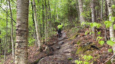
Old Speck is one of those typical gnarly mountains in the Mahoussucs. Not that is impossible, or disgustingly technical by any stretch. It's simply a mountain that heads right on up, right up a stone staircase, and rarely quits. (there are some pointless ups and downs. annoying)
OK so that's a slight exaggeration. You actually walk a bit on some nice footing and get the old muscles moving.
 |
| The warm up |
 |
| Stone stair time |
I had forgotten about the pretty water features in the first mile or so. While it was much too cold for Ellie to get in the water, she was very curious about the waterfalls and rushing h2o.
 |
| Many pretty things!! |
 |
| Definitely some snow left on the trail! |
While there were very few people on the hill, the couple that we saw descending confirmed that the rain storm we had encountered on our drive, had been a pretty decent snow squall at the summit!
In addition to the snow on the trail, we could hear the wind in the trees above us, and it did not sound friendly!!
When we reached the summit the wind was indeed there, as were the remnants of the squall. The fire tower, which always affords a good view, was too icy to climb more than half of (which I did...)
 |
| What you can't hear is the WIND!!! |
We really powered through the first downhill mile, both of us were interested in getting back into some more comfortable conditions!!
 |
| Heading DOWN |
It was still about 47 degrees at the base, so we skipped all the rituals like LAME people! No photo, no parking lot party, no post hike snacks, no fun beer. We are terrible at hiking!!
So. Overall. We were glad to be back on the trail! While this one is kind of a grind, it's still a must do for a Maine hiker. While steep, there is nothing technical (no real scrambling. nothing above treeline except the actual summit which is still kind of tree-like. nothing that made me think "oh shit, danger!!) so it is a doable hill if you have some tenacity. And warm clothing. Also, the trail is extremely easy to follow, and well marked. A nice change from some of the trails we tend to follow!
Sorry about the shit pics. I wasn't so sure I was going to keep up the hiking blogs, but, evidently, I am.
Stats:
Date:
Mileage: 7.3
Elevation: 2,852
Time: 4:32 (included 10 min stopped time)
Challenge level: Difficult, but not due to terrifying technicality
Dog Friendly?? Yes


