Sunday, August 2, 2020

Week 7: B2B2B 624K Challenge

Well I called it from day one. 
This was not the week to get anything done in the running department. 

Between having some of the WORST (and I mean, WORST) heat and humidity that I can remember, to having a BRUTAL work week, AND a sneak hay delivery (of course) I was shit at running. 

Yet another Maine morning

Even though I expected it from June 15th, it was still frustrating to miss my 30 mile running goal by so much this week. I did manage to get in the minimum mileage after a decent hiking day... But, BOOO. 

In retrospect, it may not have been a great week of running even if the stars had aligned for ultimate perfection. I was legit tired. Dragging ass. Maybe after backing off the *intense* mileage for a week, I will have lost my zombie expression.

We did have a glorious family hike yesterday. Whiteface and Passaconaway presented a good challenge on a hot day. It was nice to (sort of) unplug for a bit, and get out in nature. 

Outdoor fun day

And now, onto another busy hot/humid/hurricane??? kind of week.

And let's see. In the Challenge the silver and bronze medals have been awarded. Looks like 4th place will finish up tomorrow. I'm pretty sure that the top 5-10 placements will definitely be determined by who is willing to kill themselves in the heat. Maybe me. Like, for 10th. 

Miles run: 18.7. I am legit not amused by this. 
Miles Hiked: 11.9
B2B2B standing on Sunday night: 11/43 Gotta step it up
Hottest day: A brutal 93 degree/absurd humidity Monday. GROSS. Tuesday also sucky. The rest of the week pretty fucking hot. 
Longest run: 6.3

Sunday, July 26, 2020

Owl's Head: July 25th 2020

We live in the age of Instagram. 
Activities can only be considered successful, and interesting if there is a pretty (and perhaps heavily filtered) photo to prove your accomplishment. 

As I contemplated the many (many) complaints that I had heard about hiking Owl's Head, the biggest complaint was certainly the lack of splendor. 
No photo ops. 
No magnificent summit to pose on with friends and family. 
No bang for your buck. 

Listen. I'm not about to get all profound. But I really do not believe that success is measured in instagram likes. You can enjoy something without the carefully curated photo op.  
(and you can also enjoy the bejeebus out of sharing your adventures! Heaven knows I do. But I live for the adventure, not for the likes....)

That being said. Go like the hell out of our new YouTube Channel!! Give us SO MANY LIKES (I'm such a study in contrasts!)
Here is the progression: Our YouTube skills progress from BAD, to OK and we hope to get to DECENT. (but don't hold your breath.)

Anyway.
As we embarked on out quest to tag Owl's Head early on the morning of July 26th, I was fully prepared to suffer. I doubted that I would hate the hike, as I tend to enjoy the oddball adventures. But, I had my doubts about liking it at all.  Mostly, the things on my mind were my concerns about the potential tackling of our first bushwhack (more on that later) and my hopes that the water level readings I was seeing were correct . My biggest fear regarding this hike was NOT the low value summit, but coming to the first river crossing and having my dog swept away by the current. Luckily, it's easy enough to get the info you need about such things, and I was cautiously optimistic.

We arrived at the Lincoln Woods Trailhead before 5:30AM to find it jam packed full. We easily found road parking about 0.25 miles away, but knew it was bound to be a busy day. 

Our hike began as we knew it would, on the bone flat Lincoln Woods Trail. 
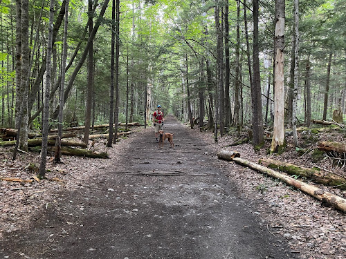
I mean.... How can you be mad about this?? #easy

At mile 2.8 we took a left onto the Black Pond Trail. I had researched the Black Pond Bushwack, and knew it would cut a bit of mileage off the hike (plus 2 major crossings and some odds-and-ends stream crossings) Armed with knowledge, the Gaia app locked and loaded, and a map and compass (although a map isn't terribly useful in this situation) we proceeded on a pretty obvious herd path. 

Which promptly vanished into the woods. 
Feeling 100% uneasy about this (even with Gaia in hand) we bailed and got the hell out. No point in flapping around in the woods all day. 
I'm not going to lie. The detour was worth it, as it was lovely. 
And it was also good to bail. If your gut tells you no, listen. 


OK. So with and extra 2 miles already in hand, we were officially off. 

I highly recommend sticking to the standard route (Lincoln Woods, Franconia Brook Trail, Lincoln Brook Trail, Owl's Head Trail) as you can totally zone out and go into autopilot.

So. It's really as easy as that. Take the bone flat super highways of Lincoln Woods and Franconia Brook. (there are a couple baby crossings on Franconia Brook) Bang a left onto Lincoln Brook. Shortly, you will hit the major river crossing (this is the one to worry about in high water, for sure.)

Big, wide river. No shoes required. 

While there are a few pointless ups and downs on this Lincoln Brook Trail, it is still extremely straightforward. After your second "real" river crossing, you will see where the Black Pond Bushwhack comes out on the left. I can see the reason of the popularity behind this *trail*. You do avoid two of the big crossings, including what is clearly the most daunting. (even though it was a low water day, we needed to wade across in shin deep water. very pleasant, it was hot.)

You spend 3.4 total miles on Lincoln Brook trail before coming to the "trail head" for Owl's Head. 
There is no sign.
On this day, there were two obvious rock cairns on the right, to mark this turn. 

Don't blink. Trail head.

Because I was keeping an eye open for them, they seemed obvious. However, 50% of the people we later met said they blew right past them (the mileage on my GPS measured the trailhead at 3.3 miles- but I do not trust devices 100% in such thick woods.) 

From there, yes. You go straight up. You gain like, 1500 feet in one mile. 

While it is a grind, it's not awful. It's a cross between Hancock and Flume slide. We all enjoyed it, if you want to know the truth. Plus, you FINALLY get your instagram photo!! (I took one! Believe me, I am not above the insta!)
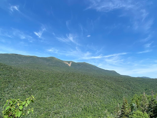
INSTAGRAM PIC

You are NOT "there" once you reach the top of the slide. You wind, and wind, and wind through the lovely woods for about .25 before you find an unassuming cairn which marks the top. 

Summit

As we made our way through the final .10 of the trail, we crossed paths with another hiker. "Did you love the epic summit?" I asked him. He laughed and said "Getting to the top of this mountain is epic enough."

That. Is. Correct. 

We did take the Brutus Bushwhack on the way down (at the BIG boulder- take a left. It is indeed a herd path and completely bypasses the slide.) 

From there, we happily retraced our steps and reentered the CHAOS of humanity once we reached Lincoln Wood Trail. THRONGS of people. (we saw fewer than a dozen people heading to Owl's head. Then at least 100 in the final mile.)
Honestly, it's weird being alone in the wilderness all day, and then return to the screaming mayhem of people (who apparently think that being outdoors excuses all kinds of bad behavior....?)
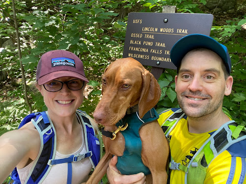
DONE

We checked back on at our car 9:50 from when we began, and the insane traffic was just too much, so off we went. 

This is one that I'm glad to have been able to check off the list. You really do need decent day to do this one- I would NOT suggest heading out after major rain, if there are storms in the forecast, or in the early spring when snow melt is an issue. 

You can easily find water data Here
People who I have talked to say that the crossings are difficult for humans when the levels are above 200, and not recommended for dogs until they are 50/60 (it was about 150 the day we went- and we all felt very, very comfortable.) 

One more word of wisdom. 
If you plan to hike ANY trails get a map, learn to use them. Get the White Mountain Guide, read it. Use internet groups to assist, but be responsible for educating yourself. If you choose to use your phone for any type of navigation, prepare for it to die and have a back up plan. (and pack your damn 10 essentials!!)

All 3 of us were pretty worn out after this adventure, but I'm feeling satisfied with the whole experience. Yes, it is a long way to walk for a 4025' hill. But getting to the summit is always half- or 99.9% of the fun, and if you love a good (FLAT) woods walk, you will love this one. 

Even Ellington was tired!!

I liked you Owl's Head. 
Next time (next time??) I will pack light, and run a good bit of this as it is a trail runners dream. I'm actually weirdly excited about trying that out. I like to be in the wilderness. I like the path less traveled. I do not like Lincoln Woods Trail in July......

Stats:
-21 miles
-3440 ft elevation gain
-9:50 min total time (at LEAST 30 min stopped time. We/Ellie need to eat.) 
-Difficulty: EASY/HARD/EASY
(don't be an idiot and try to do this one if you don't have your shit together. there is no cell service. that's all most people need to know :-)) 


Week 6: B2B2B 624K Challenge

This past week wasn't delightful in the running department, but I still managed to get it done. 

There were definitely a few REALLY hot and humid days.
While they might have been pretty to look at, it was quite unpleasant to exist in that weather. 


Despite the grossness, I still got in 30+ miles. SO: goal accomplished. Out of all the runs I did, only one way any good. Maybe 2? More like 1.5, let's be honest. 

I had reached my limit of 4:30AM wake up calls on Wednesday, and rebelliously slept in until 5:45 the following day. That meant getting in some after work miles, which wasn't terribly fun (but definitely beat getting up early that day!!) That seemed to sufficiently recharge my batteries, and I felt much better after that. 

We wrapped up the week with a 21+ mile hike to the elusive Owl's Head. A bit of a notorious mountain, because it's basically the longest hike you can imagine for a 4025 foot hill. We took advantage of some perfect conditions, and got it done. 


As expected, the first place woman in the challenge did indeed claim the crown early in the week. The second place finisher certainly could wrap things up tomorrow. 
Currently, I am sitting in 8th, but I have my doubts about whether or not that is real. With Garmin down I believe a few people are behind on loading data (you don't need to "prove" what you are doing, but I think most of us are relying on data of some sort.... and perhaps waiting to sync?) I gave up waiting and plugged my watch into the computer to get my miles loaded for complete transparency. 

Another week in the books. 
A hot, humid and busy upcoming week may preset some challenges. We shall see. 

Miles run: 32.2
Miles Hiked: 21
B2B2B standing on Sunday night: 8/43
Hottest day: A brutal 95 degree Monday
Longest run: 7

Monday, July 20, 2020

Week 5: B2B2B 624,000K Challenge

Holy. Crap.

Can I even remember last week??

Week 5 of the B2B2B was a crazy one, but I managed to get in my personal goal of 30 miles (or maybe slightly more?) All runs were done at ass o'clock, with a couple little bonus sessions with the puppy in the evening (I really wanted a day off, haha)

Two of the mornings were almost cool- a nice change!! Lots of slugs, dead frogs, and animal poop on the road in the early morning. Also, an outrageous number of deer flies. HORRIBLE.

There was a particularly nice sunrise, before a day of enormous thunderstorms.

The calm before the storm
The weekend weather was not conducive for running, hiking, living. Also, I had a horse to look after who had been subjected to major oral surgery on Friday. Hence, Eric and I sat out the weekend and missed out on bonus miles.

I feel good (maybe not while actually running) but I feel very accomplished and pleased that I have met my personal goal for this event every week since week one. I'm sure I'm also building a terrific fitness base (for something? or just for fitness!)

Miles run: 31.6
Miles Hiked: ZERO BOOOO
B2B2B standing on Sunday night: 13/43. Holding steady. The first place woman in going to win officially, tomorrow. 
Hottest day: HOT AF like, 90's both Saturday and Sunday. UGH
Longest run: 6.5

Tuesday, July 14, 2020

Mt. Adams Via Airline: June 14th 2020

It has been a funny season for hiking thus far.
Plan "A" had us wrapping up all the NH48 except the Bonds, and Owl's head during the very early Spring season. Due to COVID, we didn't even consider traveling to NH (even though it is about 4 minutes away) until June. 

Our other goal for the early season (originally planned, tentatively, to happen late June) was a full Presi with Ellie. 

Anywhoo. Weeks later now, we have postponed our Presi attempt until either:
a: a perfect day where we limit weather variables for maximum safely
OR:
b: next year. the mountains are always there

Because Mrs. Ellington was a little baby last year, we made no complete summits conquests in the Northern Presis. although we did play around Adams, just enough to stick our heads above treeline. 

After a week of the weather looking like crap, we woke up the morning on June 14th to a promising looking day, and off we went to conquer Adams, and to test Ellie's skill in the boulder field. 

It should be mentioned that Eric has beef with Adams. He kind of low-key hates it, and I can't completely argue the point. Every time we have been up there visibility has been zero. The wind has been INSANE. The rocks.... So slippery. So, Eric and Adams had a score to settle. 

We headed up Airline, as we had never done the whole trail and figured it would be a *good* time and a *great* way to tick a trail off the T25 list. Many good choices. 

Anyway. As promised it was, in fact, a decent enough day. And WEIRDLY, no wind. 

Airline was decent. Then rocky. Then kind of dumb. 

You can't judge the ups by the pic
Weirdly though, after this garbage section of trail it gets pretty decent again! Trickery. 

And.... As is the case with many of these silly hills, once you get above treeline it's a bit mind blowing. On airline, you basically teeter in space and can gawk down into the ravine and make wise choices about focusing, not tripping and falling. 

Just looking up for safety


Because I was 100% not focused on picture taking, I neglected to take a single shot of any of us making our way through the boulder field. 
But let me say this. 
It was a dry day. 
There WAS ZERO, and I mean ZERO wind. 
Visibility was as good as it gets. 
And Ellie was amazing. 

And, with GLORY in our hearts. we summited. 


Then (as you can see) we descended the boulders with success, walked over to the Madison hut, and came down Valley Way because it's easier than Airline. 

Success! A great day in the Northern Peaks. As far as T25 trails go, Airline is a piece of cake. (although you can REALLY appreciate how BAD it could be if you took a wrong step....)

We barely saw any people all day, except for a decent sized pack of noisy college aged humans. The weather was amazingly cooperative. It was a great reminder about the technical/fiddly challenges of the northern peaks that you just don't see elsewhere. AND, we were both delighted with how well the puppy handled the tricky terrain. Smart girl (and, because she is only about 45 pounds, her paws didn't even take a beating.)

Stats:
Date: June 14, 2020
Mileage: 8.5
Elevation: 4,447
Time: 5:50 (probably 20+ min of taking in the scenes, etc)
Challenge level: Difficult
Dog Friendly?? Completely, until you get above treeline. If you had issues with your dog on the way to the summit you must be aware that carrying them down could be very difficult. So proceed with caution.