Saturday, December 3, 2022

And winter returns. #5 Mt. Willey

UGH, after a glorious run, Winter arrived. 


The photo gives it away. We decided to tackle Willey for the Fall season. Last winter we tried to do it from this side and the ladders were an icy death waterfall of doom, so we bailed. They were fine this time, the trail was essentially ok (except for the fact that it's one of those trails that nobody talks about, but a good part of it is a steep little skank.)

The biggest issue with this day was the COLD. Like real full blown winter bullshit. 24 at the base, 17 at the top. Big winds scheduled for the day so we made it a one peak day, and were happy we made that choice. 


Despite the cold, it was very pretty. 


We did not linger long at the Summit. We knew the relative calm wasn't going to last, and we don't want to be anywhere near the summit when the winds start howling (we could hear them in the distance, roaring like a freight train.)

The thing about Willey is that it is quite protected until you reach the summit. On this day, we knew the trail was on the right side of the hill to avoid the better part of the wind, even if it kicked up early. We had considered adding Field as it's awfully easy to scoot over there. But nope, it was an easy choice to bail. With the temp at 17 there was just no margin for error, so away we went. 


Remember just a couple weeks back when we were hiking in tank tops? No more. 


Anyway. We made it down no problem (except my micro spikes keep catching on each other, or on my new boots. So I fell. TWICE and was PISSED.) But then we went to get a hot chocolate to cheer up after the cold cold day. 
We definitely had a conversation about how the weather was exactly what had been forecast, and how it would have been a really lousy day to head above treeline. Unfortunately, not long after we got home we heard word of a missing hiker on Franconia Ridge. Tragically, we all know how that turned out and it certainly is a good reminder to take these mountains very seriously, even it is technically still Fall.

Stats:

Peaks: 1

Miles: 5.25

Elevation: 2998

Fun: Ugh, it wasn't the most fun but that's life 

Wednesday, November 30, 2022

And... We begin again. 1-4 of round 3 of the NH48

Why not jump right back into it??

Eric, Ellie and I spent a fabulous weekend in Lincoln, NH for my early birthday. My only requests were a nice airbnb (check) lots of hiking (check) and a trip to White Mountain Wanderer to buy a couple books (check!)
We also ate some really adequate tacos (I think the place was called Nachos and it had pretty terrible yelp reviews, but we took a chance and it was absolutely fine. NOT special but it was 65 degrees out, we sat outdoors, and enjoyed our overpriced Mexican, hahah.)
We also ate some EXCELLENT coffee and bagels from White Mountain Bagel. Now that was some good stuff. 

Ellie approved of the airbnb was was very sus of the moose decoration on a mantle. Not into it. But she was very into the comfy couch. 


On Friday November 4th we restarted the 48 with a trip up Cannon in summer weather. Blue skies, 60 degrees, and only a handful of other hikers on the trail. (including the most grumpy hiker we have ever met. So grumpy!!)

It was really a glorious hike, and even Eric (who hates Cannon) had to admit that it was a very amazing day. (and it should be noted that we crushed our previous PR by a good amount!) Standard route up and down KRT, which was in the best shape one could ask for. 


The next day it started off "cool" (48) but eventually made it all the way to 66 amazing November degrees. 
It was supposed to be a very windy day up high, so we decided on the Osceolas, since they are pretty well protected and below treeline. Also, once Tripoli Road closes, they are a very long drive from where we live (and only about 20 minutes away from our AirBnb!!)

Loads of people on trail, it was a real summer day according to the crowd levels. 
We expected the crowds to lessen between peaks but it never really happened. This is what you get for picking a very popular route on such a temperate day! 
We finished in a good time, with an automatic PR since we have only done this from Greely Pond, or with the lengthy winter road walk. 


After enjoying the weirdly hot day, and the mostly very cheerful other hikers, we took off back to our temporary home to allow Ellie to spend some time with her arch nemesis, the Moose. Pure Evil.


Day 3 dawned warm. 65 actual degrees when I headed out on a coffee run at 6:30AM. Absolutely unbelievable conditions for November, and we WERE NOT SAD. (and, the clocks changed!)


And where did we go??

Owl's Head. 

Weren't we JUST THERE? 

Yes. 

But, we did not want to be the fools who left it for second to last again. Also, it was a nice fall day and really quite perfect for 16 miles. 
Despite the perfect weather it was definitely a more Fall like hike than last time. No leaves on the trees, everything a bit stark looking overall. 

Not too many others out on this trail, but we saw a handful of people tagging this silly remote peak. We had none of the struggles of traffic on the slide, but were not fast at ALL in this section due to the previous two days. Slow pokes for sure. And unlike last time, it was pretty warm at the summit so we did not have to panic and immediately put on all of our winter kit. Or any of it. 


It was a good hike, the bushwhacks were in fine shape (Brutus was a little weird- lots of blowdowns in the past couple weeks made for some funky re-routes but it all worked out.) We enjoyed the hike and did not PR at all (but we were only like, 7 minutes slower than last time which all in all is acceptable.)

We rolled back along the trail to one more Fall view before winter shows up (it's inevitable)


So Stats for the Weekend:

Peaks: 4

Miles: A little over 28

Elevation: 8466

Fun: TEN A TEN!!! SO FUN!! 


Sunday, November 20, 2022

And that's a wrap- #46-48 of round 2 of the NH48, West Bond, Bond and Bondcliffe

Well, we did it! 

October 29th was the day and the Bonds were the place to wrap up round 2 of the 48 4000 footers.

It was a fabulous day for so many reasons.

-PERFECT weather (yes, it was 27 at the start but it was well into the 60's for the majority of the hike, bluebird skies, and NOT a puff of wind!)

-Evan joined in

-We got to catch a ride with Marlene, who is a fucking legend

-We saw people dressed as those blue dudes from Avatar, and (upon seeing their costumes) we could not remember what a "loin cloth" was called, and the phrase "DICK SKIRT" was coined. We fell down laughing. Multiple times. 

-Eric did not poke his eye out with a stick, but if he had, we questioned if he would be able to see, but with a different perspective. Kind of like a go pro, or selfie stick, but direct to your own brain. Since we are rational, this led to a fairly disgusting discussion of trailside first aid (Evan is an EMT)

-We had a Very Serious Competition with a couple of men in the last 5 miles of the hike. They thought they were going to beat us to the finish, and we could not allow that. So, this hike really was sponsored by Unnecessary Competitiveness: winning. at all costs.

So on to the nitty gritty. 

We started from the Zealand trailhead around 7:20AM in brisk conditions. We had packed for cool weather because it was late October. While we did need our coats for the first few miles, they were then packed up, never to be seen or heard from again. But really, it was frosty for a hot minute. Basically until the Zealand hut. 


We passed over Zealand just to say hello- since we started with Zealand back on September 11 of 2021 we did not technically need to summit, but we did anyway to check it off for October and for Fall season. 

Once we reached Guyot we realized that it was going to be a summer day. Literally perfection. The trail was quiet, you could not have asked for a bluer sky, and the wind was ZERO. Incredible and amazing. 


You just don't get perfect days like this too often. It was an amazing hike in every way from start to finish (although something in the leaves gave Ellie a terrible scare at one point- don't know what got her but she was pretty sad for a hot second.) 
Other than that. Just a stunning and memorable time. 

West Bond was gorgeous 


Bond was pretty decent too.....


And then, just like that, we finished up on Bondcliffe. Really, one of the prettiest places out there. 


Then, the long walk down. 
1476598678 miles on Lincoln Woods trail is always a great way to finish!


Things got weird


BUT, eventually we finished and ate a whole bag of chips and a bunch of guacamole to recover. And we waited and watched our arch nemesis/people we HAD to beat, come in to the finish. Maybe someday we will just hike casually. Today was NOT THAT DAYYYYYY..

So we concluded Round 2 of the 48 much faster than round one. Just over a year, and we are pretty impressed with that considering that Ellie and I both had surgery within the last year. This hike obviously brought us to 48, and checked off all 4 peaks for October, and for Fall. It was an super time, possibly the best from this round. 

Stats:

Miles: 19.25

Elevation: 4250

Fun: TEN, A SOLID TEN!!!!

Thursday, October 20, 2022

Tuckerman's Ravine and Boott Spur with Ellie

Way back this summer, on August 14th, Eric was taking a Wilderness first Aid class at Pinkham Notch. Ellie and I were feeling like it was a good day for a hike, and decided to take a day to hike on the path less traveled. 

The plan: 
-Tuckerman's Ravine, but only to the ravine. I had never been there, and was curious to stand at the base of it and take a look around. 
-then, take the Boott Spur Link
-summit Boott Spur
-return on the Boott Spur Trail

Big Big adventure.

We arrived pretty early at a packed Pinkham Notch Visitor's Center, and I was somewhat carsick because Eric had driven hastily over Hurricane Mountain Road, which is like a roller coaster. Gross. Either way, Eric hustled off to his class, and Ellen and I took to the hills.

Overall, my rating of the Tuckerman's Ravine Trail to the actual Ravine is not terribly high. After passing by the Crystal Cascades- which were lovely, the trail was not terribly exciting. 


It would be a high quality winter trail though- gradual and wide. Ellie and I saw a decent number of hikers both ascending to Washington and descending from their backpacking adventures. 

Anyway, we ambled along, enjoyed the day, and appreciated that the river crossings were very well bridged. (the water was low, but these crossings still looked tricky!) As we got closer, we caught a view of where we were headed. 


After passing by the hut, the trail got super steep! We definitely got a good warm up for the rest of the day in this section. 
It was pretty cool checking out the Ravine. It was steeper than any photo gives it credit for, and certainly looked like it would be a long and damp climb to get out of there. 


After checking it out, we made our way back DOWN the steepness to the next step off our day. 

The Boott Spur link trail was easy to find, down by the large hut. Many people were there, but for the remainder of my day, I only saw 4 people (yay, goal accomplished! Always striving to take the quiet road.)

Let me tell you WHAT. The Boott Spur Link is STEEP. SO VERY STEEP. After a short time, I looked DOWN to see where we had come from and I was like F**K!!!
This is a terrible photo but that is the hut that I JUST came from. Ellie was leaping and bounding and pumped about the steep ascent- but even SHE was panting. I was laboring along like a 96 year old woman and kept stopping to say "SHIT! TOO STEEP!" It was steep. THE END. 


We climbed, and climbed and popped above treeline and climbed MORE! For a hot minute I was thinking that the above treeline section of the link was one of the most exposed/steep trails that I had been on in a while. Then, thankfully, it settled down. 


Once on the actual Boott Spur trail there was still a good bit of climbing to go, but it was on a somewhat more reasonable incline. And it was beautiful! Definitely a gorgeous vantage point, and so so quiet on this particular day. 

After summiting, we took a few minutes for a snack and a sit-down. I hadn't calculated how much total elevation we would be doing in this hike, but at this point I was thinking "a lot"- especially for a medium distance hike. 


Descending, more steepness, as one would expect. Still a really cool trail though, very pretty and very enjoyable. 


We were beat at the end of this monster day. 


You think to yourself- "it's not going to be that bad, we aren't even technically tagging any summits!" But this one is a good workout. Definitely a great one if you want to get above treeline without a huge crowd, and a good training hike for SURE. Lots of VERT. Also, very very pretty, from the waterfall, to the views of both Tucks and Huntington's ravine- really impressive!

THEN Ellie and I went to the local brewery for a burger and the weirdest stranger interaction story of the summer happened! This random man and his children wandered over to see Ellie while I was eating (all good!) but then when I got out of my seat to let the kids interact, the father STOLE my seat and spend twenty minutes telling me about how amazing he was. He was good at: running, getting covid, overcoming covid ("Overcoming things is what I am BEST AT!!") hiking, and just everything- from what I was told. Want to know what he was not good at? Letting me eat my lunch (I should have just told him to get out of my chair, I hate that I fell into the trap of having to "be nice" because that is shit.) I eventually grabbed my plate and kept on eating while saying "oh wow. that is great. so much skill." Jesus Christ. One might have thought that he was looking for a new spouse, but his existing spouse was at an adjacent table, and my conclusion was that he really LOVED himself and wanted all the strangers to know about the greatness. Ellen and I were not sad to make new friends once they left, and we immediately became friends with a couple who had Rhodesian Ridgebacks (who kindly allowed me to eat AND listen to their stories, hahah...) 

Stats:

Miles: 7.8

Elevation: 4028 (not flat) (plus you gain like 800 feet in less than a half mile on that stupid link)

Fun: A solid 8.5- good weather, amazing views, a heck of a workout 


Sunday, October 9, 2022

Owls Head: #45 of Round 2 of the NH48

We had every intention of trying to finish this round of the 48 several months ago. Our pie in the sky goal was to finish it prior to summer! 
Life had other plans though, and between BOTH Eric and I needing time off to cope with injuries, and some weather that was just too hot for hiking this Summer (and things like work getting in the way) we have been left this Fall with JUST Owls Head and the Bonds.

Yeah. Just a couple little walks.....

Things finally lined up for us to tackle Owls Head on Saturday, October 8th. Yep, a Saturday in peak foliage, on a holiday weekend, when there are several major tourist attractions happening (Fryeburg Fair, and Loon Resort was hosting what appeared to be a major Octoberfest.) All of this being taken into account, we decided to seize the day and make the best of it. Fall weather had been rolling in hot (cold), the water levels seemed to be nice and low, and it was a solid day to be on the trails before ice and snow become a concern. 

We don't haul ass to get on the hill anymore, and we arrived at the overflowing Lincoln Woods lot around 8AM. 

We learned a lot from our last Owls head excursion- which was in the summer of 2020. During that trip I had a number of concerns, mainly having to do with hearing tales of terrifying fast flowing river crossings, hard to follow bushwhacks, the steep and sketchy slide, and the overall length of the hike. I would say, that for round one of the 48, there was no mountain that gave me more worry than Owls Head. 
I'm not going to say that they were for nothing. Armed with ZERO confidence, we quickly abandoned the Black Point bushwhack when it became hard to follow. Then, taking the long way around, we certainly discovered that the numerous river crossings were time consuming, even of a day when it was warm and the water was not too high. That day we were out for a staggering 10 hours, logging over 20 miles due to our backtracking from the failed bushwhack attempt, and then taking the long route. 

New year, new us, new plan. 
I didn't even track the water levels, as it has been a pretty dry 10 days. We went in with complete confidence that we could follow the bushwhack and make it a 16 mile day. And armed with this positive mindset, off we went. 

Really, the hike went off without a hitch. 


We blazed along the Lincoln woods trail, cruised up Black pond and found (and followed!) the bushwhack easily. To be honest, it is a more pleasant route than many of the maintained trails we use, and Gaia locks right on to the track. Very safe and very enjoyable. And Black Pond is just lovely. 


Clearly, we bypassed several river crossings, including the largest, but as expected the water levels were very reasonable- actually, on the low side. 

The trek up Lincoln Brook trail is partially a wet slog, but we still made short work of it. The final river crossings were simple rock hops, and we were at the base of Owls Head trail before we knew it. 


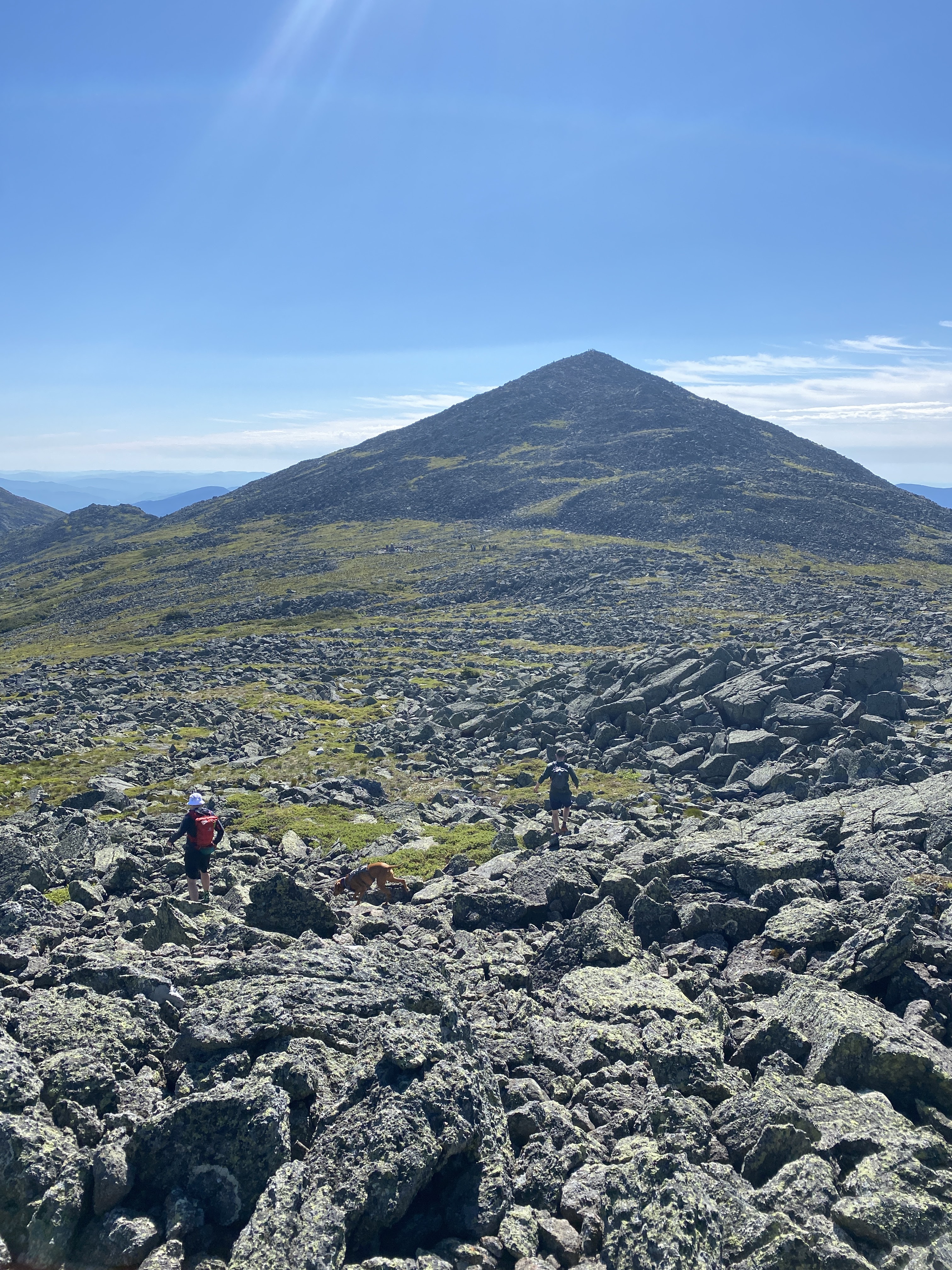
Of course, that final mile gains over 1500 feet of elevation so it is no joke. However, this particular slide is not all that bad. Some crappy scree and loose rocks give way to a bit of easy scrambling, and then just more steep climbing. It is a cardio nightmare, but not (for me) terrifying. 

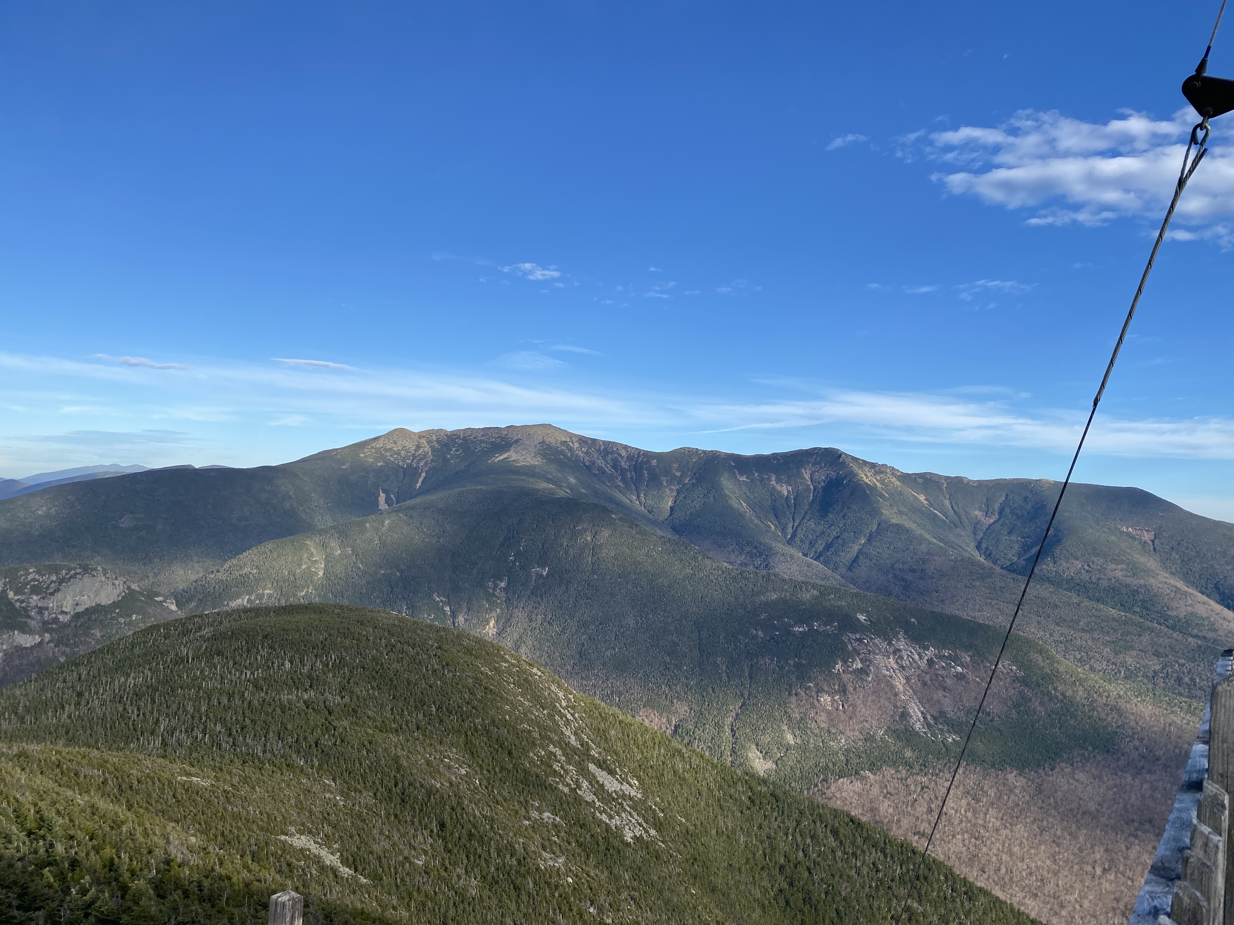
There are also impressive views of Franconia Ridge which is fun to see from this perspective. Literally in the MIDDLE of the Pemi Wilderness looking up at their massive bulk is pretty cool.


As it turned out, the only hiker traffic we saw all day was in the slide zone, and there were enough hikers to form a few bottlenecks. This may be hard to imagine, in a place this remote, but we clearly were not the only ones taking advantage of a pleasant and dry autumn day. 

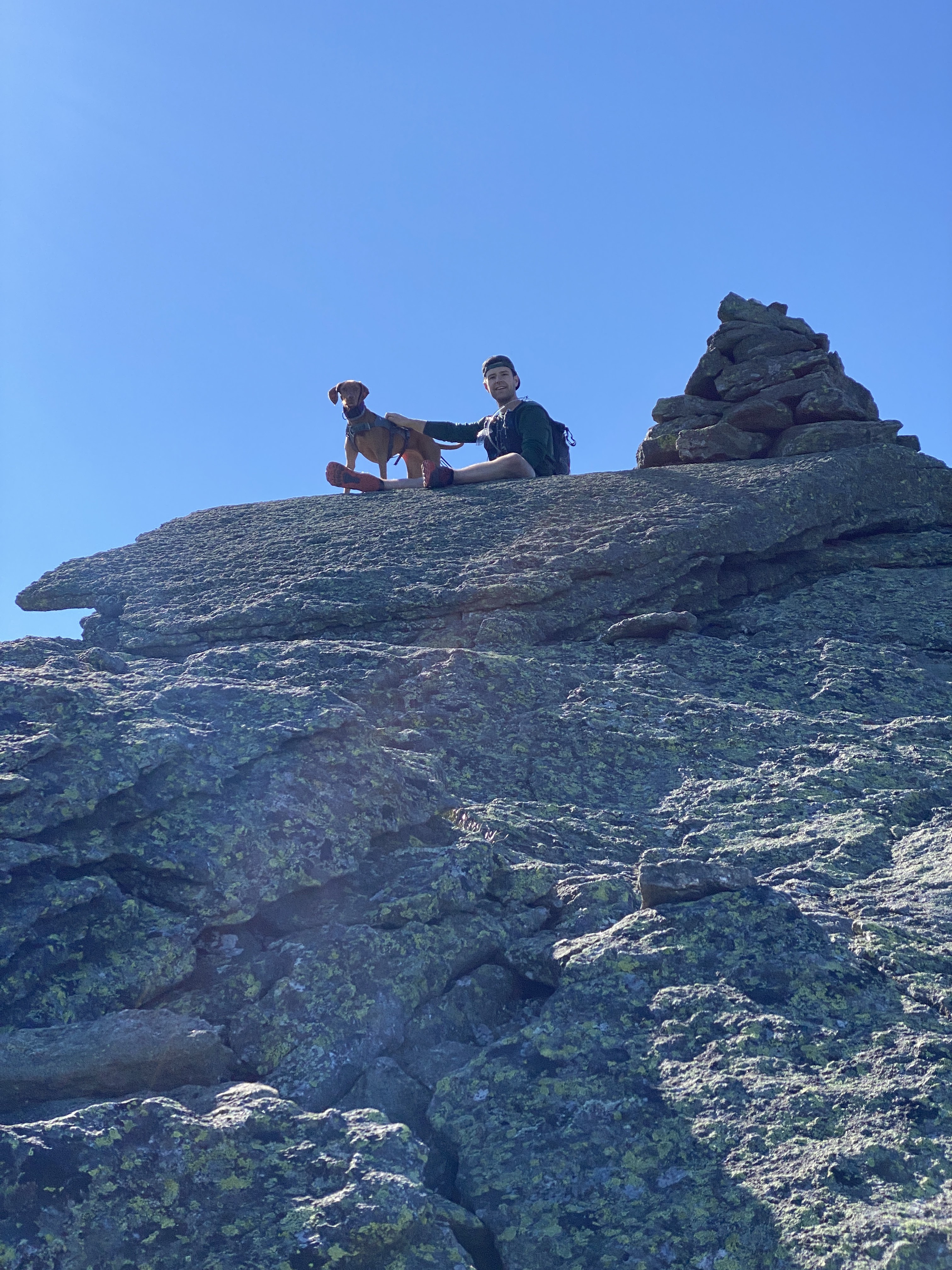
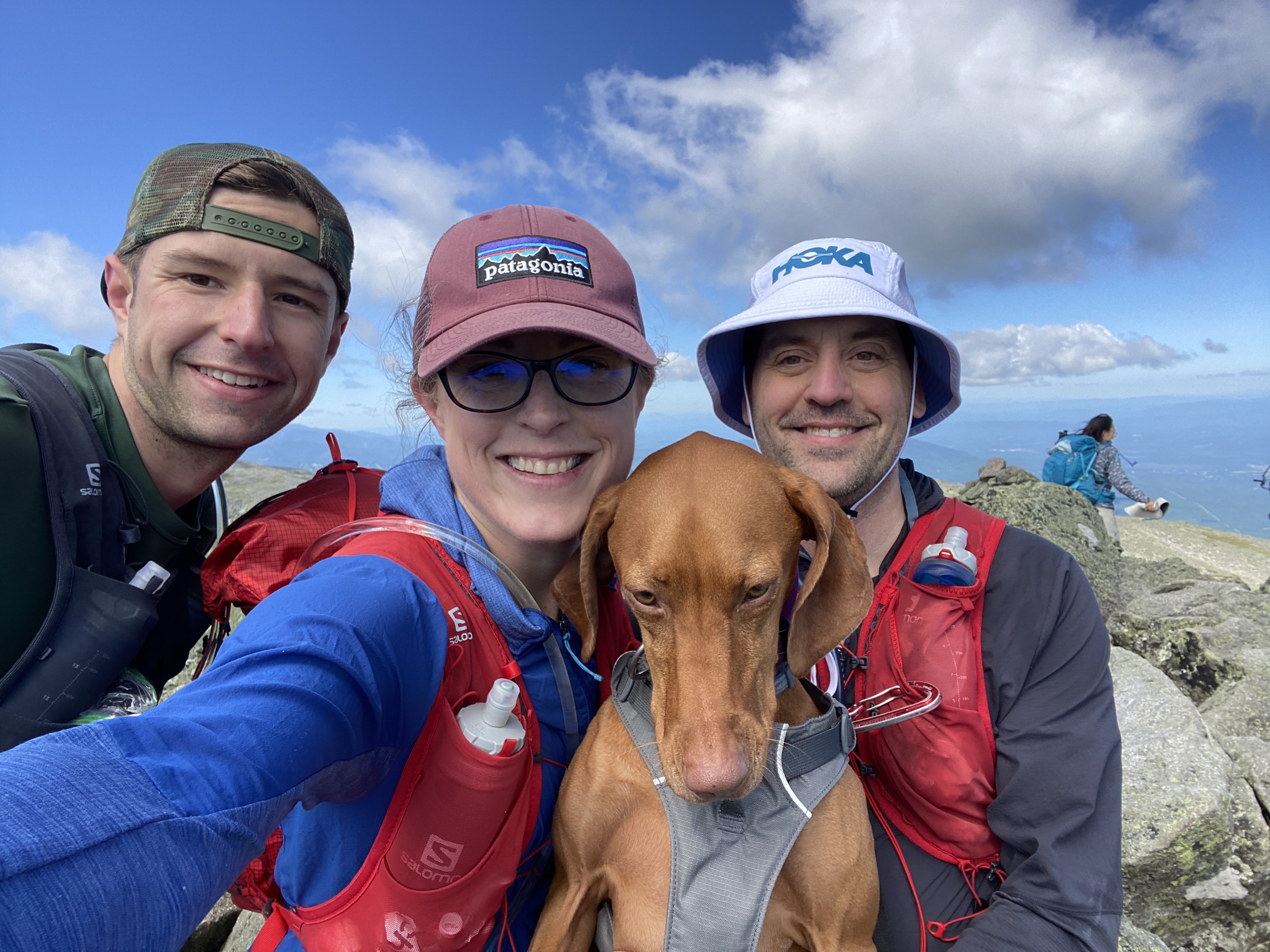
The final annoying "serpentine though the woods to the summit" was a quiet stretch, and chilly, with signs of frost and the temps dipping to freezing. Ellie and I put on our jackets!

The summit of Owls Head is a low value one. High value hike, low payback summit. 


It was too cold to hang about and we took off after a 7 minute break. 


We encountered some traffic from people escaping the bottlenecked slide, and then scooted down the Brutus Bushwhack and quieter traffic conditions. Brutus was in above average condition, and even though it's a steep steep ballbuster of a descent, it beats going down the slide.

We had a pleasant, quiet and enjoyable walk back and admired the lovely fall conditions. 


Once back to Lincoln Woods, the quiet ended and it was all out tourist pandemonium. 

We escaped quickly to our car, clocking in at just under 7 hours, and just over 16 miles. Tired, but happy. 

It then took us 4 hours to make the normally 1:20 drive home, due to aforementioned tourists and fall time events. Luckily, it was a nice day for a drive. 

Weirdly, Owls Head is a favorite of mine. I love a nice long walk in the woods, punctuated by a brutal uphill mile! 

This brought us to #45, and ticked off Owls Head for Fall, and for October. 

ONE MORE HIKE TO GO.

Stats:

Miles: 16.2

Elevation: 3300

Time: 6:50:19

Fun:
Sara: 9.5
Eric: 7.5

Wednesday, October 5, 2022

Passaconaway and Whiteface. On two different days. #43 & 44

For whatever reason, we did not feel like cracking out Passaconaway and Whiteface in one fell swoop this time around (probably because it's not really a terrific hike.) (or because we want to see an occasional new trail) (or other, who knows)

So, as we do, we headed out for two separate hikes (one for 10 miles, one for 7) instead of just cutting to the chase and grinding out the whole mess in one 11 miler. Logic. 

We hiked Passaconaway on the hot and toasty July 4th, came across a wildfire (really) and saw hardly another soul on the trail. 
It should be noted that we did not find a wildfire and then casually go hiking. A ranger came in right away and let us know that it was fine if we stayed, and perfectly fine to park. This wildfire, although an acre in size, was more of a smolder than a raging inferno (thank heavens!)


We headed up Oliverian Brook trail (very pleasant) to the Passaconaway cutoff, eventually connecting to the ledge trail, and summiting on the walden trail (I think.... I feel like it was less complex than this sounds!) The only people we saw were hiking the loop, and after a few summit encounters we saw a grand total of zero people on the descent. 


The wildfire was still smoking along at the finish. It was a very strange thing too see, started by a renegade firework (not cool)

Total distance: 10.6 miles
Elevation: 3110
Fun: 9 


The next week we headed out on a dry and sunny day to smash Whiteface. We headed both up AND down  Blueberry Ledge trail (the ledges are totally fine to descend when dry!) 
No good story here. We made short work of it, even though it was a grind. 


Eric ended up having some miserable foot problems that then sidelined us for a good bit of time. With Owls Head and the Bonds left, nobody wants to find themselves in the middle of the wilderness with lousy feet. 


Miles: 7.9
Elevation: 3048
Fun- I had a good time, so an 8. Eric hurt his feel so a 2

Anyway. 44 down, 4 to go. 

Thursday, September 15, 2022

The Adams Family

We had the chance to hike with Evan on July 3rd, and instead of dragging him along to slog Owl's head (or similar) we opted for an above treeline adventure on the path less traveled. 

The weather was projected to be amazing (yes) and it was a holiday weekend (a big one) so we knew it could be wild if we went with a standard choice. 

Appalachia was already jam packed when we drove by, but barely anyone had parked at Lowe's Store. In fact, we only saw one descending hiker until we made it to Thunderstorm Junction. 

So for those of you who don't know- The Adams 5 consists of the Big Kid- Mt Adams, and his family, Abigail, JQ, Sam and FIVE. Poor five kind of missed out on the naming. 

So first of all you climb for a good long time up Lowe's Path, pop above treeline, and scoot up and over Abigail Adams. 


From Abigail, you go off path for a bit and climb the obvious prominence to the right, which is Sam Adams. Sadly, we did not bring a Sam Adams to drink (also, it was like 9:15 AM which is early..) The whole trip up and down was just straightforward rock-hopping, very easy to completely avoid the vegetation.


After the summit of Sam, we headed to Thunderstorm Junction, and proceeded to take Gulfside around the looming mass of Adams. 


After the intersection to proceed up Adams, just a short way in, we took a detour to the left to conquer JQ Adams. A fun little rock hop, not at all unlike the rest of the trail! 


From there we kind of raced up Adams Adams because the trail was a little congested. A quick stop at the top to recover, and we were off to our last peak of the day. 


From Adams Adams, wer descended along Lowe's path back to Thunderstorm Junction, and then took a left onto Gulfside. Not long after the Junction of Israel Ridge Path, we found little forgotten about Adams 5, and took the short walk to its summit. We enjoyed a little lunch, and then made our descent. 


We (again) took the path less popular- and saw not a soul. Israel Ridge path took us to the Perch Path (and shelter- which is a nice site!) We then took Randolph Path, before, (eventually) getting back on Lowes. 

PHEW! This was an awesome day but definitely a big adventure, with all the rock hopping and multi peaking. We did have a wonderful time though, and it was an awesome above treeline day!

Stats:

Miles: 11.1

Elevation: 4940, no wonder we were tired

Time: 7:16:37

Fun:
Sara: I'm just saying it was a 10 of a day1
Eric:

Mt Washington #42 for round 2 of the NH48

On June 25th we headed off to tag Washington, since it (and Ellie's feet) had eluded us earlier in the season. 

As it turned out, it was Race the Cog day- where a few intrepid and crazy fools race the train up the hill. 

Basically, we did the same thing. We headed up the Jewell Trail with the hopes of catching the lead pack as they made their way up the crappy cog trail. 

It was a lovely day. Warmer than expected (actually hitting 70!) with very little wind. 


Surprisingly, we saw no other hikers while making the climb. 


Much to our delight- we were indeed able to catch a glimpse of the winning runner in the final stretch. Bunch of tough people- no way I could run up that hill in under an hour!


It was quite busy at the summit, so after watching a few finishers, and taking in the view from all sides, were made our way down. 


We chose to take the Cog "trail" to continue cheering on our friends- and I can't really recommend that as a route! Pretty much a drag- but great fun being the cheer squad. 

We finished feeling good, and happy to have enjoyed a really gorgeous day in the mountains. 

Stats:

Miles: 7.5

Elevation: 3747

Time: 4:03:05

Fun:
Sara: 8 (only because the cog "trail" sucks)
Eric: 9